
Red Light and Stop Line
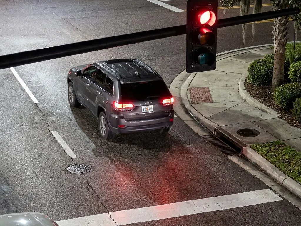
Signal-correlated red-light running and stop-line infringement across every lane on the approach.

Traffic video analytics for public safety has to produce a case, not a clip. Single-camera enforcement sees a moment. IREX coordinates cameras across an intersection, correlates vehicle movement with the traffic light and with pedestrians and produces a case an authority can actually act on.
Why Multi-Camera
Whether a vehicle ran a red light depends on where it was when the signal changed, which lane it was in and whether a pedestrian was in the crossing. That is several cameras and a signal feed, correlated. IREX coordinates them, tracks vehicles across all lanes on the approach and ties movement to traffic-light status and pedestrian activity.
This was recognized as a world first: in January 2025 IREX shipped the first cloud-based multi-camera traffic management system. In production, one city deployment detected 2.3 million violations in a single year and Mongolia runs the first nationwide multi-camera traffic-enforcement deployment, including Ulaanbaatar.
Enforcement is also where camera specifications stop being negotiable. IREX publishes installation specifications per violation type, built around defined camera roles, with field-of-view rules such as the stop line falling in the second third of the frame for entry LPR cameras and pedestrian cameras covering the crossing plus 8 to 10 meters either side.
Coverage
Signal-correlated red-light running and stop-line infringement across every lane on the approach.
Driving in the opposite lane (wrong-way driving; the violation type was renamed Opposite lane in version 4.40), overtaking where it is prohibited (captured since 4.40) and forbidden maneuvers at intersections.
Failure to yield to pedestrians and near misses where no contact occurs.
Parking violations and hard-shoulder breakdowns, against a permissible stop time you enter in seconds on the no-stop area.
Average speed between a start line and an end line on a road segment, against a speed limit and a tolerance you set.
Crossing violations, with its own camera installation specification.
Dedicated motorbike detection with rider count and helmet detection, restricted-zone rules and BikeLaneTrack for bike-lane monitoring.
See Two-Wheeler Analytics →CarCount jam detection on a road segment you draw and parking-lot capacity alerts, alongside traffic and crowd heatmaps with average-speed statistics.
In Operation
A violation assembles its own evidence: the plate read, the vehicle context, the signal state, the timestamps, the camera identities and the clip. The wide shot is measured rather than guessed: since version 4.40 the full frame that precedes a line crossing is taken when the vehicle is three license-plate widths from the line, replacing a rule that derived the distance from the vehicle width and could leave a large vehicle outside its own evidence frame. Transit priority and yield-violation cases work the same way. The point is that nobody compiles the package by hand, because manual compilation is where enforcement programs stall.
An enforcement program is only as good as the system that issues the citation, so the report is a push rather than a download. An export task is defined once in the settings, filtered by violation type, road object and tags, with vehicle lists named as exceptions and it sends the violations that match to a URL you enter, as a JSON file: one descriptor per event carrying the road object with its address and coordinates, the violation name and type, the plate number and state, the vehicle color, make and type with their recognition scores, the observing cameras and the snapshots inside the file itself. A task runs streaming, meaning every violation as it is detected, or daily and a daily task can be confined to time windows set per day of the week and overridden on named dates, with a 24-hour report still available to pull by hand when something is urgent. Delivery is then settled by response code: a 200 completes it and the file is never sent again, a 400 stops it and a 401 or a 500 is retried every 5 minutes for up to 30 minutes or until a 200 comes back, so a receiver that is briefly down does not cost an agency a case.
See the Export Format in the Docs ↗
The speed violation IREX documents is a section measurement. The road object is a linear road segment rather than an intersection and two traffic objects are drawn in CarTrack Pro on the cameras watching it: a Speed control: Start line and a Speed control: End line, either on one camera or on two. The violation rule carries the length of the segment between them, the speed limit and a permissible tolerance you enter and the platform divides that length by the interval between the two line-crossing timestamps to get the vehicle’s space mean speed. The violation type is Space mean speed above limit, the name operators see is the one you type when you create it and because the whole section is what gets measured, braking for the camera and accelerating past it does not help. It is the same figure Mongolia’s nationwide deployment reports as average speed between intersections.

On Camera
Three more of the classes above, on camera: a vehicle that fails to yield, a highway lane blocked after a collision and a two-wheeler where it should not be.

The right-of-way detector carries both halves of the problem: the citable failure to yield and the near miss where no contact occurs and a city would otherwise never hear about it.

A collision and a breakdown need the same response from a control room, so they raise the same event class. The blocked lane, the timestamps and the clip arrive with it, for an operator to verify.

Dedicated motorbike detection covers what a car-shaped model misses. A motorbike on the sidewalk is a restricted-zone rule written with the vehicle class and the same read carries the rider count and the helmet check.
See Two-Wheeler Analytics →The Read Underneath
Multi-camera enforcement is the workflow. License plate recognition is what it is built on and three things it does are the reason these violation types work at all.
The same pass returns the vehicle class, the body color and the make alongside the plate characters. Class is what a restriction is actually written in: light, medium and heavy-duty trucks became separate categories in release 4.36 precisely so weight-restricted and lane-restricted zones could be enforced and two-wheelers became their own class in 4.36, with rider counting and helmet detection on the same read.
Some rules are about which vehicles belong in a lane rather than what a vehicle did. Release 4.38 added plate number templates: a violation rule on a road segment names the vehicle lists and the plate patterns permitted there, so a transit corridor can be policed consistently and anything else in that lane arrives as an exception with evidence attached. The failure-to-yield-to-transit rules shipped on the same mechanism.
A camera watching an approach can answer a paperwork question as well as a behavior one. Inside a check area drawn on that camera, each plate is matched against DMV registration or another authorized dataset your agency supplies and a lapsed registration raises a Registration expired event in the same violation list as the red-light and stop-line cases.
CarCount
Not every traffic question is an enforcement question. CarCount answers two operational ones: is this road segment jammed and is this parking lot over capacity. It counts vehicles inside a region of interest you draw and raises an event when a threshold you set is crossed. It does not identify or classify them and we would rather be precise about that here than have it come up in a pilot.
Where It Runs
The same coordinated cameras answer a different question depending on who owns the road. These are the verticals where multi-camera enforcement is the defining requirement rather than an extra.
The full enforcement and congestion program for a road authority, in production nationwide in Mongolia and across Peru and Southern California.
Read More →Violation and congestion data as one layer of a city’s operating picture, shared across the services that have to act on it.
Read More →The vehicle side of an investigation: a plate of interest, a route across the network and an evidence package a case file can carry.
Read More →Illegal-stop rules and lot-full thresholds on garages, decks and surface lots, with plate-controlled entry at the barrier.
Read More →Railway-crossing violations, which carry their own camera installation specification alongside the road ones.
Read More →Customs corridors and the vehicle lanes at a crossing, where the same read answers a compliance question as well as a behavior one.
Read More →Keep Reading
One approach, instrumented properly, tells you more about a citywide program than a hundred cameras guessed at.
That is what the per-violation installation specifications exist for: defined camera roles, positions, angles, resolutions and field-of-view rules, verified in a site survey before deployment. The platform then assembles the plate photo, vehicle context, signal state, timestamps, camera identities and video clip into one package automatically.
Sometimes. General analytics run on the standard platform baseline, but enforcement has stricter optics requirements. Technical specifications for these deployments run 1920 × 1080 up to 2560 × 1920 at 12 to 25 fps, H.264 or H.265 at 1 to 6 Mbps with constant bit rate preferred, ONVIF Profile S or G, PoE, IP66 and a −30 °C to +40 °C range. Cameras outside that may need replacing or supplementing.
Not from CarCount and it matters that we say so plainly. CarCount counts vehicles inside a region you draw and raises an event when a jam or a parking threshold is crossed. It reports no throughput figure, no per-lane or directional count and no vehicle classes. Vehicle make, model, color and type come from the plate and vehicle read this page is built on and the wider object taxonomy from ObjectTrack Pro. If a program needs classified counts as a report rather than as a search, raise it before the pilot rather than after it.
Two lines and the distance between them. The start and end lines are traffic objects drawn in CarTrack Pro on the cameras watching that stretch of road and both can sit on one camera or on two, with the cameras bound to the road segment under the Average speed camera type. The crossing timestamps come back as attributes of the line-crossing events those cameras detect; the segment length, the speed limit and the permissible tolerance are entered on the violation rule and the space mean speed is computed from them. What the site has to provide is the same enforcement-grade optics every other violation type needs, which is what the per-violation installation specification covers.
No. CarCount is documented as fixed cameras only, with no PTZ, phone uploads, or drones, because its thresholds are measured inside a region drawn on a frame that does not move. It wants 1280 × 720 to 2592 × 1944 at 10 to 30 fps, a mount 3 to 15 m above ground and more than 25 pixels per meter inside that region. A small-object mode takes the minimum vehicle outline down to 16 × 16 px for traffic further from the camera.
Yes. All vehicle types are supported including two-wheelers, with dedicated motorbike detection, rider counting and helmet detection and BikeLaneTrack covers bike-lane monitoring.
It runs on its own and alerts a person. Detections are signals for a human to verify: no response runs autonomously and the verification and decision are logged against the same Case ID as the detection.